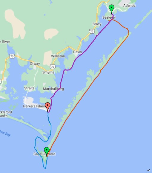
This week, myself and another paddler completed a 54.77 mile circumnavigation around Cape Lookout. This trip was special for my partner, as it marks the completion of his quest to circumnavigate all the barrier islands on the North Carolina Coast.
Finding a proper weather window proved elusive and, as is often the case, the trip evolved several times in the days leading up to it, as deteriorating weather and problematic tide times forced us to change the trip several times in the days leading up to it.
Many Failed Attempts
Prior to our successful completion, there were 5 previous attempts, which had to be called due to weather.
The most recent two were due to two named storms, Arthur and Bertha, tropical storms, both of which occurred before the start of the 2020 Hurricane Season. In the case of Bertha, it was named only 2 hours before the storm made landfall in South Carolina, although we had already canceled the trip due to bad conditions.
As an aside, while we did cancel the trip, we did a short day paddle in both named storms this year.
Planning and Perpetration
When planning a trip like this, you are usually too far out to have reliable weather reports, so you start with finding a tide window that will work. Then, as the time draws closer, you begin to factor in weather, swell/sea state, ete into your planning process.
Unfortunately, in the case of this trip, while the tides were right for the first attempt, when we started pushing the dates out, it changed up the tide schedule, so that it was less than ideal for the 5.75 mile out Barden Inlet and then entering Drum Inlet.
After calling off our first two attempts this year due to named tropical storms, last week, Monday – Tuesday looked pretty flat, with Wednesday slightly elevated and so we found our window.
Due to scheduling conflicts, we could not get an early start on Monday and with low tide early in the morning both Monday and Tuesday, we would need to wait until around noon to exit Barden Inlet, to avoid fighting what is usually a very strong current through the narrow inlet.
We discussed a few options, including launching late in the day one Tuesday and then paddling a short day on Tuesday, with most of our ocean side paddling occurring on Wednesday. However, this would mean a largely wasted day, so we ultimately decided that we would camp in sea level Tuesday, then get an early start and shoot for paddling soundside south out Drum inlet. This would complete our soundside paddle and then the next two days would be ocean side.
We both had been watching the weather, using various data points, including the National Weather Service(NWS) Coastal Forecast, Windy, Magic Seaweed, etc for weeks and over the weekend, the conditions on Wednesday, as well as later in the week, had begun deteriorating, with a very strong wind predicted.
Concerned about the building conditions, given that we were planning on being oceanside Wednesday and possibly Thursday, we decided to reverse the trip and get a late start on Monday, with the goal being to get out Barden Inlet and then as far as possible. Then, ideally get inside Drum inlet by Tuesday, so that we could avoid the strong winds and elevated conditions for Wednesday.
While this plan helped us avoid the building conditions, the downside of reversing the trip in this manner is that it would put us paddling into a strong headwind on our last day.
Day One: A Late Start
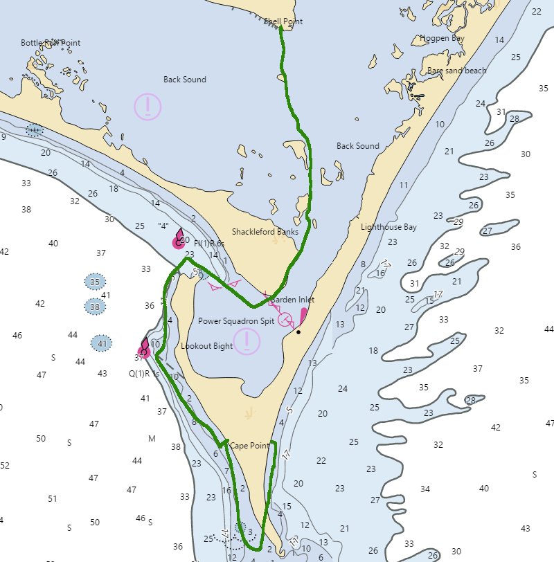
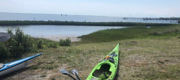
On Monday afternoon, we drove to Harkers Island and off loaded our boats, getting on the water by around 3:30 PM. This was later than we wanted, but given the tides, allowed for an easy paddle out of the inlet. We made good time, over 5 MPH average, to the inlet, then were met with calm seas.
Our main goal achieved, we then began paddling ocean side around Cape Lookout Bite and towards the Cape. We did not have a set goal for the day, other than getting out of the inlet, but each mile that we paddled on our first day, would help us get to Drum Inlet quicker, so we began to paddle in earnest. After paddling approximately 3.3 miles from the inlet, we took our first beach landing.
Around the cape, there is a long sandbar, which depending on the tides and conditions, can mean that you have to go rather far out to get around to the other side of Cape Lookout. We had seen several boats go around and they were swinging wide around the cape, so with the winds often becoming stronger towards the end of the day and not being sure how far we would need to go out, we considered camping here.
However, as we were scouting for a camp site on a small dune, we were able to get a pretty clear view of the cape and it looked much closer and relatively calm. So, after taking one more look, we decided we would try to get around the cape before camping.
Water was a little rougher as we neared and then passed around the cape, but manageable. After another 4 miles, which put us about 1.7 miles from the lighthouse, we decided to do another beach landing to camp.
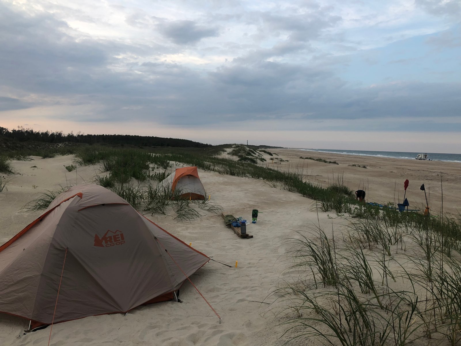
After what ended up being a rather long carry to the dunes, we made camp, ate, and then retired for the night.
Day 1 Stats:
- Total Distance: 12.3 miles
- Average Speed: 3.6 MPH
- Moving Average: 4.07 MPH
- Duration: 3 hours, 27 minutes, and 18 seconds
Day 2: Finishing Ocean Side
We woke early on Tuesday, ate breakfast, broke camp, and were on the water by around 7:10 AM.
Conditions on Wednesday had deteriorated and by the time we launched on Tuesday morning, NWS had conditions being 3-5 feet, with elevated winds, and a small craft advisory beginning in the afternoon.
We knew that we really needed to get through Drum Inlet and off oceanside as soon as possible and given the deteriorating conditions, did not want to spend another night oceanside.
However, the tides were not in our favor, so to get in the inlet, we would need to arrive at the inlet by around 12, otherwise, we might have to wait until after 6PM or waste a lot of energy fighting the current to make it through the inlet.
We estimated we were about 20 miles from the inlet, which if we paddled hard was doable, although would mean few breaks.
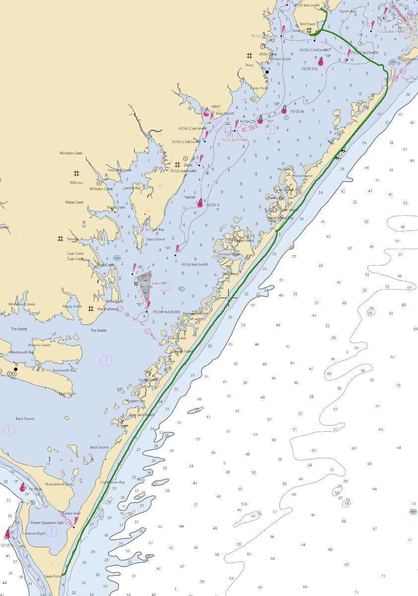
With a 5-10 Knot South wind pushing us, we made good time and made a beach landing after about 13 miles when we reached the Great Island Fishing Cabins. Here we stopped for a short break, scouted the sound-side access point, as one option for camping tonight was paddling back south again to the cabins, ate some snacks. We were both accosted by rather large stinging bugs here.
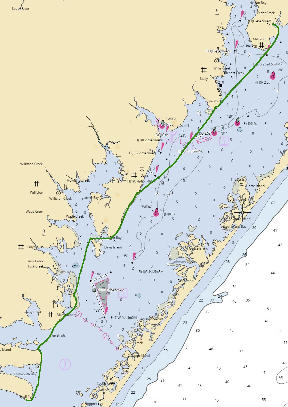
After a short break, we hopped back in our boats to paddle the remaining 6 miles to Drum inlet. As we neared the inlet, there was some shoaling and shore break near the inlet, but we found a clear path and paddled through. Despite our concerns, the tide had not changed yet and this would be our fastest mile, as we reached speeds of around 6 or 7 MPH on our way through the inlet.
For Tuesday, we had discussed paddling six miles back to the cabins sound-side, however ultimately decided to head to a campground in Sea Level that we had camped at before on previous trips. We stopped briefly after entering the inlet and called the campground to make sure they had availability, then made a roughly 2 mile crossing to get to Sea Level.
Prior to the trip, Lee had gotten a bearing on the campground of 310 degrees, however after talking with the property owner, we changed this a bit to closer to 300 degrees. Unfortunately, this caused us to overshoot the campground and so after consulting a map again, paddled back about 1/4 miles to the campground.
Day 2 Stats:
- Total Distance: 24.97 miles
- Average Speed: 3.5 MPH
- Moving Average: 3.79 MPH
- Duration: 7 hours, 5 minutes, and 16 seconds
Day 3: Heavy Winds and a Broken Paddle
Our third day was sound side, so we were protected from the sea conditions, which had built overnight. However, there was a small craft advisory in effect and very heavy wind, which unfortunately would be in our face the entire day.
After breaking camp, we began making our way south back towards Harkers Island, where our vehicle was parked.
Windy had predicted a consistent wind of around 12 – 15 knots with gusts up to 16 – 21 knots for our final day and while anecdotally I’ve found the free version of Windy to be massively inaccurate, especially in recent years as they’ve further limited what models are available in the free version of the app, this was pretty close to what we experienced.
With the heavy winds and easy stopping points afforded by a soundside paddle, we made many stops along the way, stopping at least 6 times during our 9 hour paddle. Even with that, our moving average was pretty close to our overall average, which was around 44% slower than previous days due to the heavy wind.
During a rather long crossing near Davis Island, I also experienced a paddle failure. While paddling, I felt the paddle start to slip around, with the blade loosing traction, like my hand slipped and the handle turned. This was in the middle of the crossing and I managed to power through it, but stopped as soon as was safely possible to checkout the paddle.
Upon inspection, I discovered that the insert of my Lendal Cadence Paddle, which is what slides inside the other half of the paddle, had become loose and as a result, the insert was twisting with each stroke.
I believe this may have first become damaged during a paddle of the tiderace at Plum Gut in New York, where I had heard a slight popping sound while playing in the race. The heavy exertion and high winds most likely put it over the edge. Fortunately, it had not completely broken and so I was able to make it across the bay and swap with the spare paddle I was carrying.
Ultimately, I would end up getting this warranty replaced and even with this experience, still prefer the Lendal to my Warner paddle, due to the superior lever lock found in Lendal paddles.
After paddling several more hours and facing a strong wind, only broken periodically when we were able to put some trees between ourselves and the strong gusts, we arrived back at Harkers Island.
A food truck awaited us and we both enjoyed some greasy food truck delicacies, made all the better by our long strenuous day.
Day 3 Stats:
- Total Distance: 17.5 miles
- Average Speed: 1.9 MPH
- Moving Average: 2.12 MPH
- Duration: 9 hours, 18 minutes, and 8 seconds
Final Thoughts
This was an interesting trip, not only because it represented the final chapter in my colleagues quest to circumnavigate all barrier islands in North Carolina, but also due to the challenges completing it.
Not only were there a number of failed attempts, which had to be called due to poor weather conditions, we skirted building conditions on this final attempt and our final day, despite being protected paddling, proved to be very difficult due to the heavy winds.
This is a beautiful area to explore and contains some interesting tidal conditions.